By Richard V. Pouyat, Ph.D. Emeritus Scientist, U.S. Forest Service
Richard V. Pouyat has been involved in conducting research in urban ecosystems for over 30 years. While he was pulling together a presentation for Los Angeles Urban Soil Symposium (hosted by TreePeople), he asked himself, what has he learned about urban soils while working in the field. He goes into the last three topics here:
4. Spatially, urban landscapes represent a “new heterogeneity” of soil characteristics
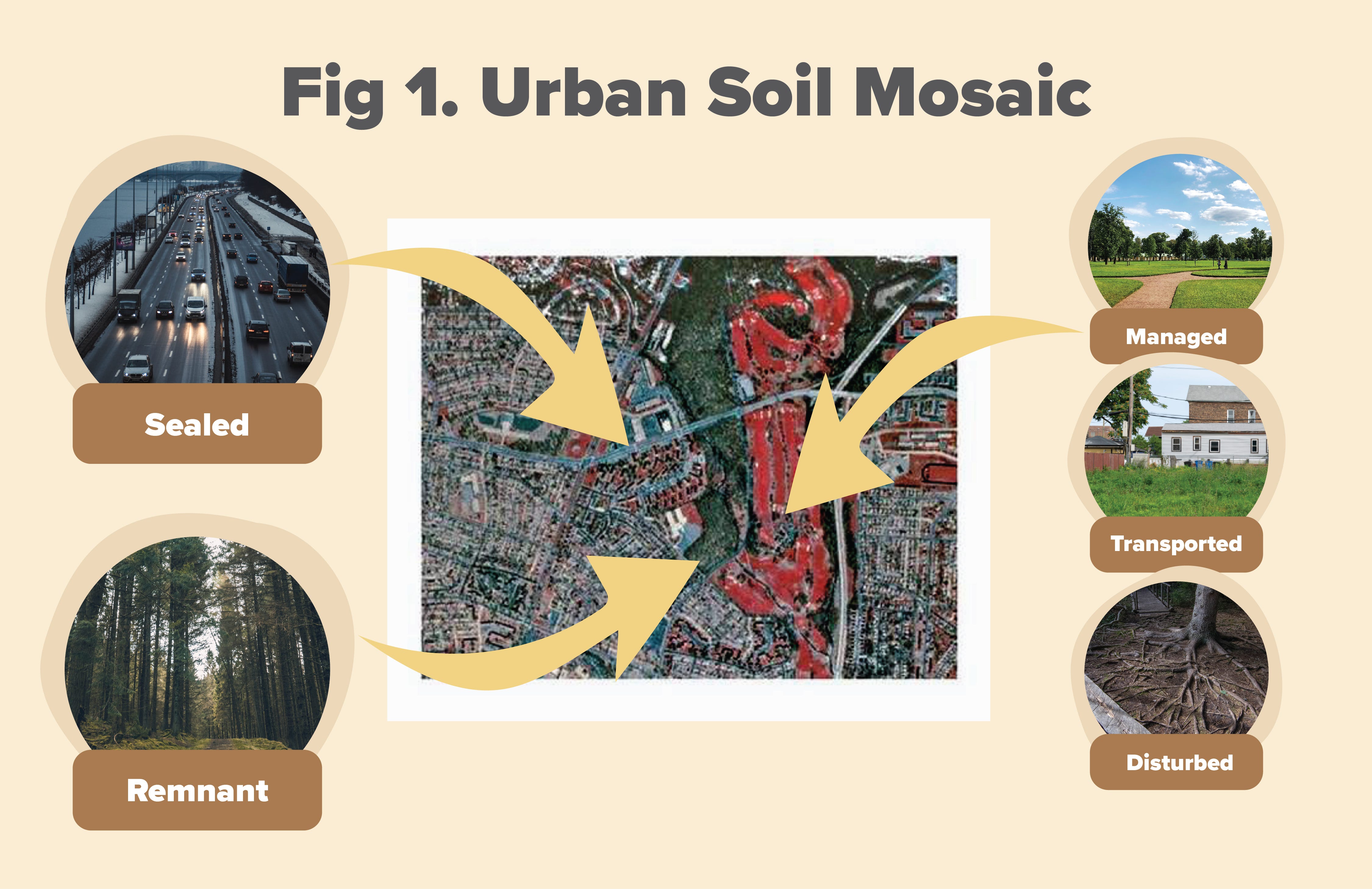
As I pointed out in my previous blog, there’s a new paradigm in pedology (a branch of soil science focused on the formation of soil, its characteristics, and classification) where humans are now considered as a separate soil forming factor, which really regulates the “health” of the soil found in urban areas, and perhaps more importantly, the status of soil health is in space and time. You can think of it as human impacts on soil are not the same everywhere and those impacts can either take a long time to show a measurable effect, or take a long time to recover from a big impact that occurred in the past. So if we take a birds eye view of an urban area, we can see the results of the “a”, or human factor, throughout that landscape for a particular point in time (Fig. 1).
And what we see is what I call the “urban soil mosaic”, which looks like a patchy surface that follows land ownership boundaries with different site histories, leaving a mixture of relatively “natural” soils, and as my soil scientist colleagues in the USDA-Natural Resources Conservation Service (NRCS) would refer to as Human Altered and Human Transported, or HAHT soils. Looking down at the urban mosaic, we can see soils situated in “remnant” forest, shrub, and grass land patches; sealed by impervious surfaces; associated with highly managed lawns; and of course HAHT soils (refer to my last blog for more examples and information on urban soil conditions). This mosaic of soil conditions represents to a soil scientist what I refer to as a “new heterogeneity”; it is new because until there were cities being built by humans, this birds eye view of soil conditions was never seen before on the Earth’s surface, and soil scientists are still trying to be able to predict where and when you would find various soil conditions in an urbanized area. This in comparison to forest, shrub, and grass land areas that have undergone minimal human impacts and where a knowledgeable soil scientist can map hundreds of acres of soils in a single day because they have knowledge of the soil forming factors mentioned in my last blog. In urban areas, the original soil forming factors only tell a small part of the story — the “a” factor is now overriding them to a large degree.
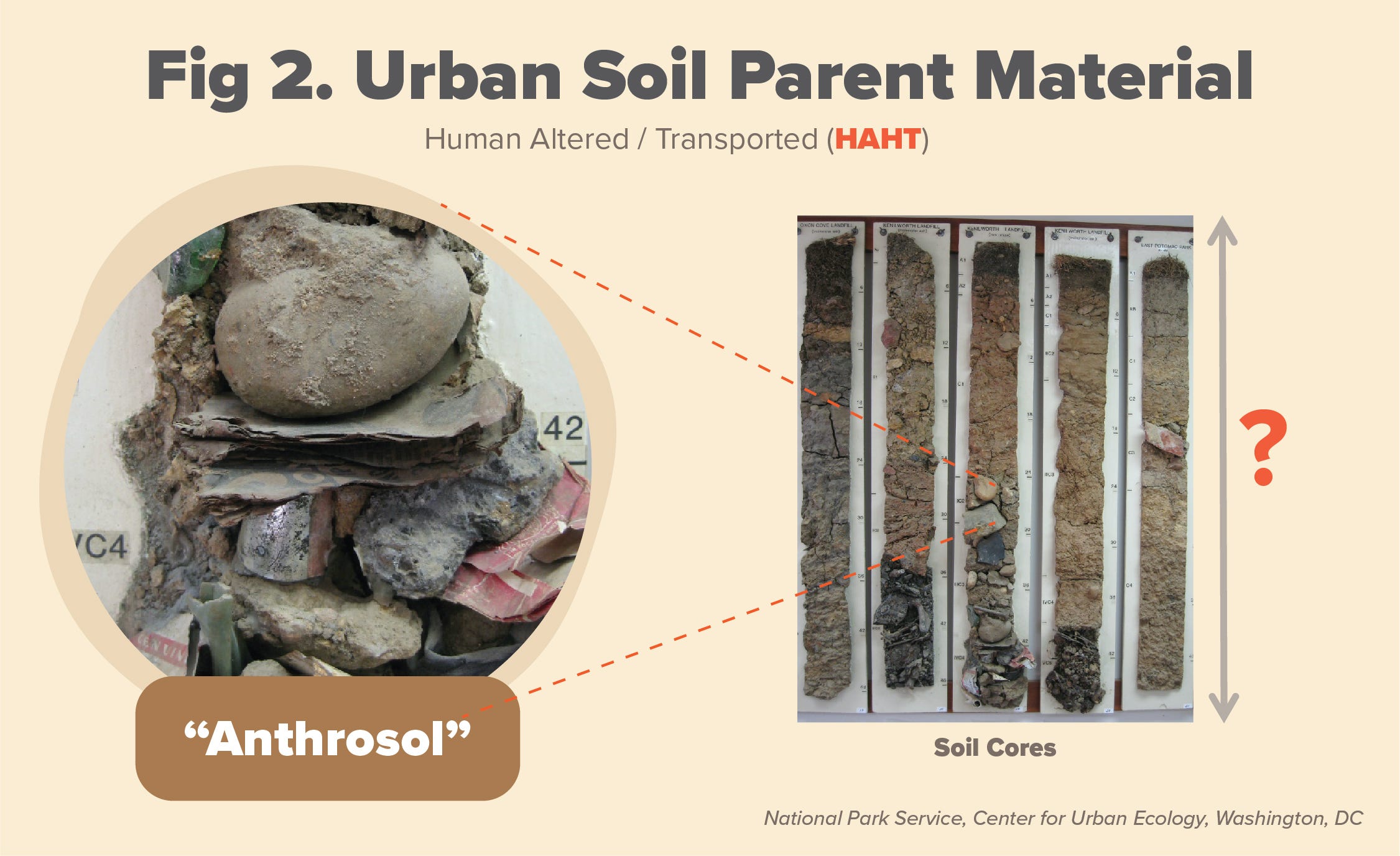
Soil scientists are only now trying to be able to predict the impact of the “a” factor in space and time. We are getting there, but have a long way to go. There is also a “new heterogeneity” with urban soil in the vertical perspective, which is primarily due to human disturbances and transported materials. Indeed, humans have altered natural horizons (or layers) of soils and introduced new parent materials and artifacts (Fig. 2). How soil scientists use these human introduced materials in describing and classifying soils (by looking at heterogeneity in the vertical) is an active area of research.
From the horizontal perspective, it is one thing to map discrete soil units or patches on the landscape as is done in a soil survey (see Fig. 1), but another to quantify the spatial heterogeneity of various soil characteristics in urban areas. For example, lead (Pb) contamination of soil in urban areas is a widespread problem due to use of Pb based paint and gasoline in the United States for decades (the topic of another blog). If we could predict where Pb contamination is most likely to occur in urban areas (or hot spots) that would be a good thing. In fact, we can do this by developing predictive mathematical models, which can then be used for developing policy, driving planning decisions, and identifying hot spots in the urban landscape.
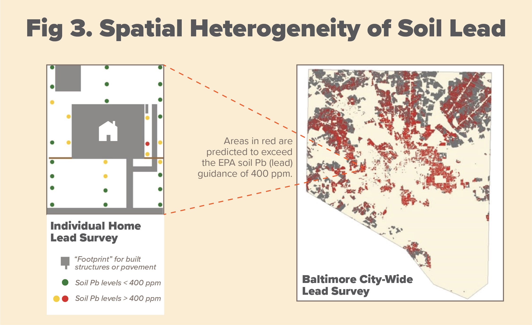
A good example, shown in Fig. 3, is a map of surface soil Pb concentrations in Baltimore, MD. By taking thousands of surface soil measurements, using X-ray fluorescence or XRF technology, Schwarz and others (2013) were able to develop a statistical model with 40% accuracy using only 3 variables — not bad for an urban mosaic that is thought of as being extremely variable! Red areas in the map are concentrations predicted to be above 400 ppm — a critical soil screening level for bare soils by the Environmental Protection Agency (EPA).
5. Urban effects on soils can go way beyond the boundaries of urban areas
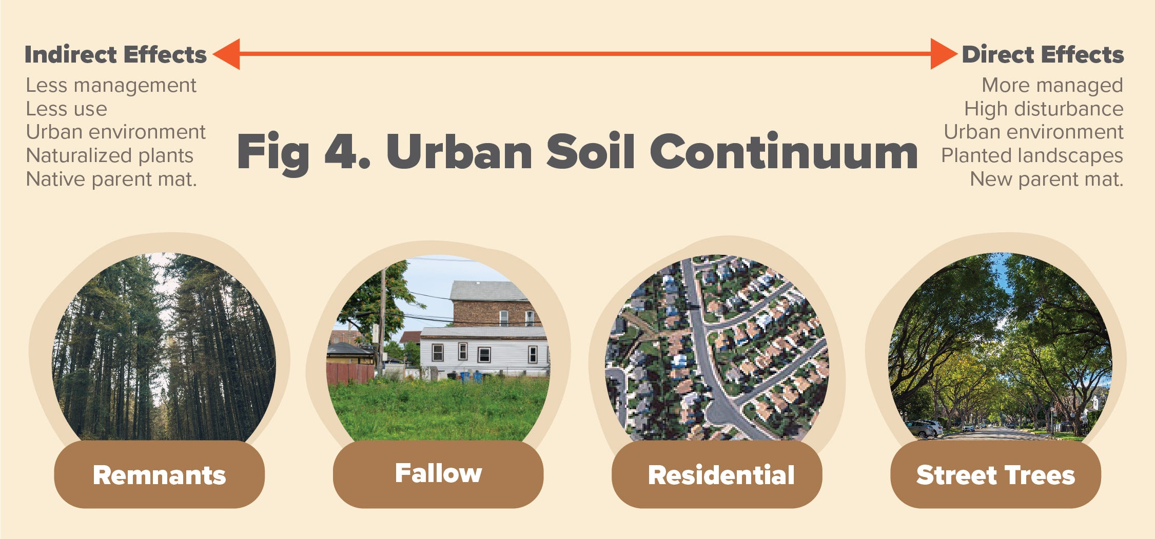
This relates to an urban environmental effect such as air pollution, which can travel many miles “downwind” of a city. I consider environmental effects to be “indirect” in that they take a long time to exhibit a measurable response in soils. By contrast, “direct” effects are physical in nature and happen in a relatively short time. The combination of both direct and indirect effects makes up the “urban soil continuum” with a gradation of human impacts going from the most to least impacted soils (Fig. 4). A good example of an indirect effect that may occur many miles downwind of a city is again Pb concentrations measured in soils, but this time in forests found along a transect from an urban to rural area (or “urban-rural gradient”).
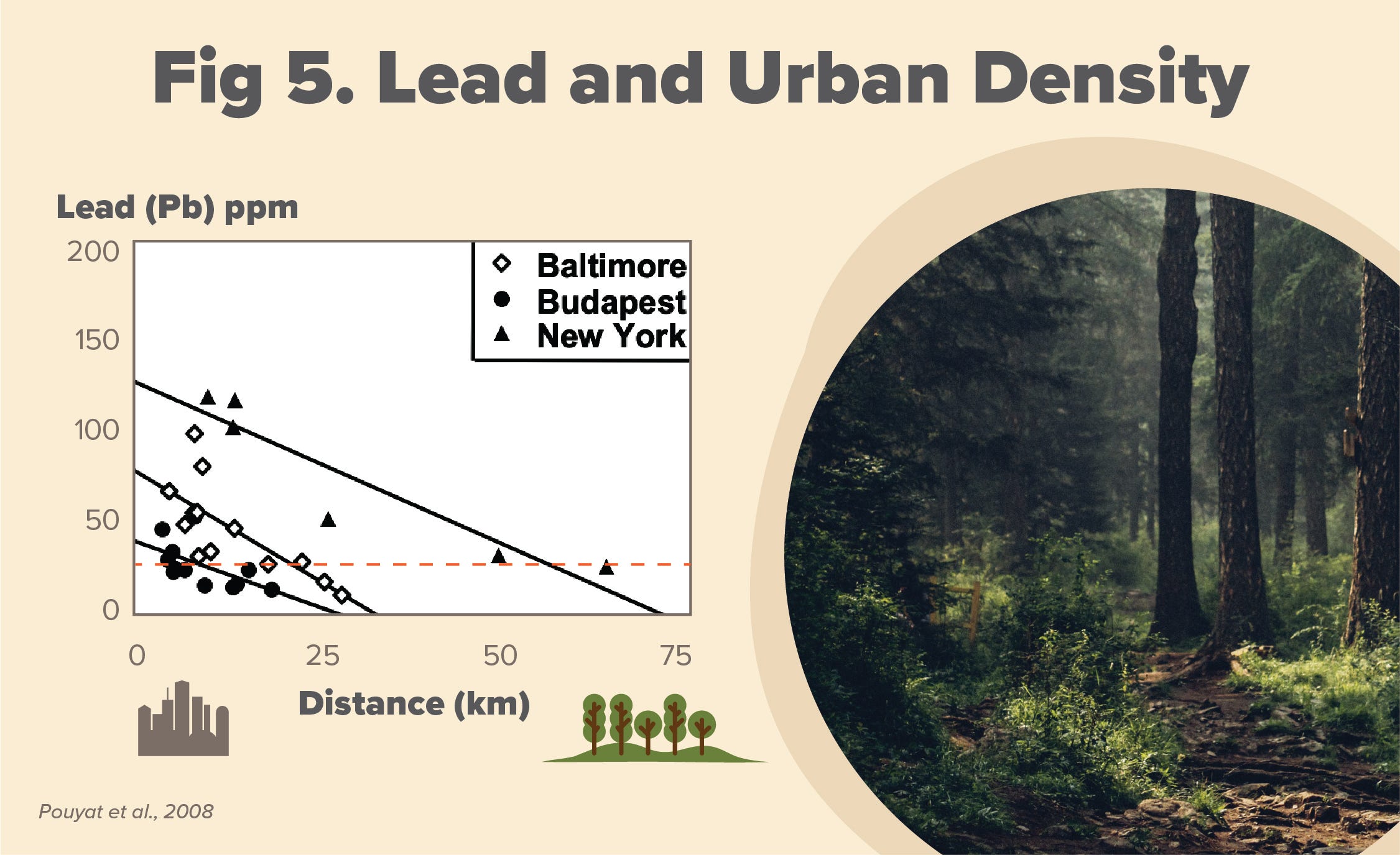
Fig. 5 depicts a comparison of urban-rural gradients in three cities differing in population and area. Note the relationship of Pb in soil with distance to urban core (using distance as a surrogate for “urbaness”). New York City in particular has far reaching effects (between 25–50 kms), due to its development pattern and size of densely populated area. Other indirect effects on soils have been measured along urban-rural gradients, including the amount of nitrogen (N) being deposited by atmospheric deposition and the temperature of soil being impacted by the urban heat island effect. In the Los Angeles region, air pollution is a particularly important “indirect effect” of urbanization. And again, much more research is needed to understand how far reaching these indirect effects may have on soils in metropolitan areas of different population densities and cultural factors.
6. Finally, the need to address the intersection of soil and people
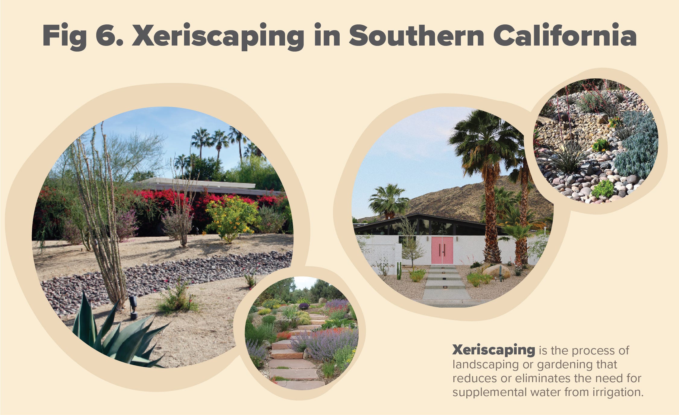
The close proximity of soils to people in urban areas (around 80% of population in the United States) greatly increases the importance of potential health hazards (as was shown earlier with Pb in soil) and achieving ecosystem services (refer to my last blog). Additionally, this close proximity between people and soil offers an opportunity for teaching science, technology, engineering and mathematics (STEM). For example, recognized sub-disciplines in soil science — soil chemistry, soil physics, soil biology, and soil ecology can all be taught utilizing soil that can be found in any school yard within a city. And because human activities have the potential for huge impacts on soil development and their characteristics, we must understand why people do what they do when managing a landscape and why they do it. For example, land owner decisions on whether to have a lawn or specific tree species can have immense implications to urban footprints (see my last blog for discussion on urban footprints). For example, deciding to have a xeriscaped yard instead of a lawn (Fig. 6).
So there you have it — my “what have I learned about urban soils in a 30 year career”! I am looking forward to learning even more during TreePeople’s “Healthy Soils for Healthy Community” initiative. Please join us as we learn more about the health of urban soils in the Los Angeles region.